Monday, June 30, 2008

Smack My Map Up

I've yet to run into a program that I couldn't install on 64-bit Vista. The latest challenge I've taken on is Map 3D 2009.

Disclaimer: If you attempt the following procedure, you are on your own. Autodesk will not support these "hacked" versions. I am just putting this out there for your information - I assume no responsibility for this not working for you, your lost time or hair.

This is how I beat Map3D 09 into submission:

  1. Download Orca.msi.
  2. Copy the Contents of the Map DVD to a hard drive (you can delete this after the install is complete).
  3. Browse to the (x86) folder and open ACADMAP.msi with Orca. (After Orca is installed you should be able to right-click on this and select Edit with Orca.)
  4. There are three locations to delete in this MSI file. Table: Custom Action Action: Checkfor64bitOS, Table: InstallExecuteSequence Action: Checkfor64bitOS and Table: LaunchCondition Condition: VersionNT >= 500 AND NOT VersionNT64.
  5. Save and close the modified MSI file.
  6. Run the install by double-clicking the MSI file. I recommend installing to default locations.
  7. Lastly, we have to move some resources that were placed in the wrong location. Browse to C:\Program Files\Autocad Map3D 2009 and move the entire folder to the C:\Program Files (x86) directory.
  8. Click YES to merge folders if it asks.

You should be good to go from there.
Friday, June 27, 2008

Doing a Little Remodeling

I just added Google analytics to my blogs and decided to use the opportunity to freshen up the look of things. Feel free to comment on the new layout.

Thursday, June 26, 2008

Profile Style Weirdness


I have so much on my mind this week, I'm so glad I finally have some time to blog.


This first post is regarding a funny "gotcha" in the profile styles.


It all started when I was doing some one-on-one training on P&P sheets for a client and he wanted all of his profile views to have a vertical exaggeration of 5x, rather than the default found in the OOTB templates of 10x.


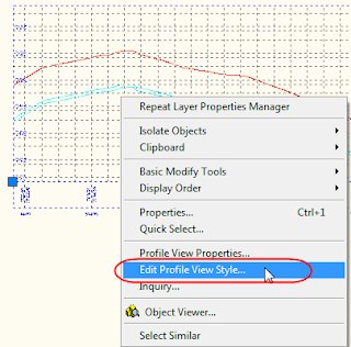
To change this I went to the profile view style by right-clicking on the view.


I jumped to the Graph tab and set the vertical exaggeration to 5 and thought I was home free. In theory, I'm changing the style that is active for all the profiles. The funny thing was that all the profiles changed except for the one I had right-clicked on.


After tinkering and repressing my curse reflex in front of a client I discovered that even though the profile in question was not being split, it was grabbing the style as if it were.


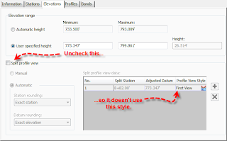
To fix it, I went to the Profile View Properties and unchecked the Split Profile View option.

A different way to solve it, if you are always going to have a 5x exaggeration anyway is to change all of your styles to be the scale you want. Just make sure to go into them via the Settings tab - 'cuz right-clicking the object won't get you to the correct style!


The same info applies to both 2008 and 2009 Civil 3D. Hope this saves someone some grief.

Monday, June 16, 2008

Survey Tools for Map 3D 2009 Subscription Customers

Are you a Map user on subscription? Keep an eye on the Subscription website for several new tools to make you more productive. The new tools will be available for download starting June 27th,2008.

I have been trying out the new surveying tools add-in for Map. There are several new COGO commands to enhance what we have on the Input and Inquiry toolbar. Those commands include a Bearing/Bearing transparent command, and a Distance/Distance transparent command.

In my opinion, the most significant thing the survey add-in allows users to do is to create a GeoTIFF from point data. DTM is back, and better than ever. In plain English, that means you can make a 3D surface right in Map.

In the following screen shot, you see the surface’s data being added from an external text file or FDO source containing contours.


You can add break lines to a surface right through the Display Manager in the Task Pane. Best of all, you can export the surface using LandXML to share with a Civil 3D user.

This is a great step forward for Map users who may have been considering the jump to Civil 3D.

SQOTD: Layer Toolbar Empty and Other Weirdness

Q: Hello,
I am having a few problems with my CAD right now.
1. When I click on any item in my drawings the layer manager does not tell
me what layer that item is on.
2. I can not edit the text in a Civil 3D general note that was just added to a
drawing.


A:
There are a few things to check:

  1. Type PICKADD at the command line. The default value for Civil 3D should be 1. Generally people like this on, but if you are used to working with it off it would throw you off. If more than one object is selected, your layer toolbar will not show the object's layer (it will just be blank). It also would prevent you from editing a Civil 3D general note. If it is set to 1, hit ESC a few times and try again.
  2. If that doesn't do it, check the PICKFIRST setting. The value for this should be 1.
  3. If that isn't it, go into the full Layer manager and click Settings. Turn off the toggle for "Apply Layer Filter to Layer Toolbar". What this means is if you have a layer filter active and you click on something that is not part of the filter, your toolbar will be blank.
  4. Next, check the Noun/Verb selection setting. In Options > Selection Tab make sure there is a check mark next to Noun/Verb Selection.
  5. Lastly, if none of the above is the answer, run a repair install.

Note: In this situation the PICKFIRST variable was the answer.

Sunday, June 08, 2008

How to Rename Your Tool Palettes

There's a story behind this post. So last Wednesday at our user group meeting I was demoing the new features of Civil 3D 2009. I was showing the group the new assemblies that are ready-made and how easy it is to drag and drop assemblies into the tool palette now. So I'm on the screen as shown at left and Rick L. (hi, Rick if you are reading this!) notices the second tab down is truncating itself in an unfortunate way.


Honest, I created this tab to read "My Assemblies."


So it might be a good idea to show people how to create new palettes and rename them.


All you need to do is right-click on any existing tab. You'll see New Palette in there as well as Rename Palette. Pretty simple.
One of these days I'll create a 4-star post on how to network tool palettes such that users can have thier own but a CAD manager-type can dish out read-only, company-wide ones.
For now, I'll keep it mellow.


Tuesday, June 03, 2008

The End of Land Desktop (+ New Product Announcement)

It's true. There will be no such thing as Land Desktop 2010.


Autodesk officially announces today that the current release of Land Desktop and its close relative Civil Design will no longer be upgraded or available in future releases. In other words, 2009 is the last year Land Desktop and Civil Design will be available.


What does that mean to you?
It depends.


If you are already primarily using Civil 3D as your drafting/design product, you are ahead of the game. Civil 3D will not loose the ability to convert legacy projects from Land Desktop.


If you are on subscription but still using Land Desktop things get a little more interesting. You will receive support through the end of your subscription - however you will no longer receive updates. This would be a great time to contact your reseller about cross grading to Civil 3D 2009 or the new product: Autocad Civil 2009.


If you are not on subscription and decide to upgrade after July 8th 2008, you will just get a Civil 3D 2009 disk. Land Desktop Companion will only be a downloadable product for subscription customers after July 8th.


What are your options?
The good news is that Autodesk is putting out a new product called AutoCAD Civil 2009. This is essentially a version of Civil 3D 2009, minus the Map and Hydraflow functionality. This product is meant to work in tandem with Civil 3D with seamless round-tripping of data between the two. If you've ever wished you could upgrade all your base AutoCAD seats to Civil 3D - but couldn't due to the price, AutoCAD Civil is your go-between.


Is this a good thing?
Yes! Both the Land Desktop freeze and the new AutoCAD Civil product are positive developments. If you are a Land Desktop user, you've already noticed the conspicuous lack of new functionality over the past few years. With the focus now on the newer technology in AutoCAD Civil 3D and AutoCAD Civil we will see many more enhancements and improvements in the years to come. The AutoCAD Civil product is a less expensive option for users who do not need the heavy-duty analysis tools in full Civil 3D.


Where can I learn more?
This week I expect Autodesk to publish an FAQ regarding these changes. When that becomes available I will post a link ASAP. In the meantime, give your local reseller a call.

Monday, June 02, 2008

Civil 3D User Group Wednesday, June 4th 2008

Topic: Louisa Holland will speak on new features in Civil 3D 2009.

Location: Quality Inn
2969 Cahill Main Madison WI 53711

Date and Time: Wednesday June 4th, 11:30am-1:00pm
Registration is required!

Lunch will be provided by MasterGraphics.