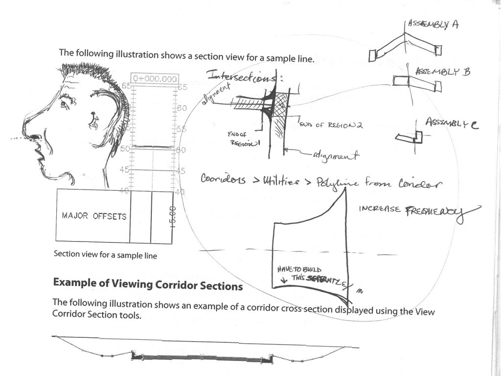
Friday, December 29, 2006

Chapter Zero: Importing Points from a Text File

Level of Difficulty:

In this post we are going to import a text file into Civil 3D. The following is an excerpt from this file.


1,5477.4814,3886.3451,122.9931,BM001
2,5554.5536,4234.3339,107.7749,IPF
3,5528.4406,3804.3077,129.1600,FENCE
4,5523.5055,3795.4675,129.3400,FENCE
5,5522.0336,3787.1183,129.2100,FENCE


The file is a simple Point Number, Northing, Easting, Elevation, and Descriptions file, commonly referred to as an ASCII file.

1) First, go to File > New in Civil 3D.


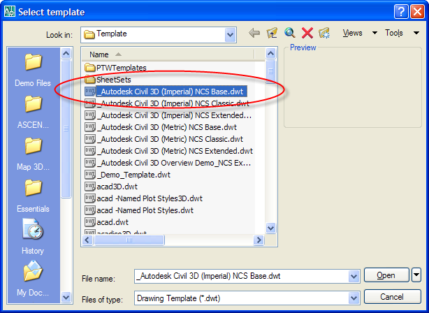
2) Select the Template file called _Autodesk Civil 3D (Imperial)NCS Base.dwt
3) Click Open

We are starting a new drawing with a template that will contain all the needed styles for this exercise.

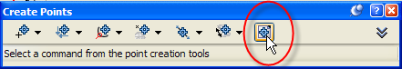
4) On the Prospector Tab, find Points
5) Right-click on points and select Create…


6) Click the Import Points icon.


7) Verify that the format is set to PNDEZD (comma delimited)
8) Browse for the source file.
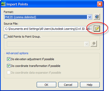


9) Click OK
10) Zoom Extents to see the newly imported points.

Next we are going to change the look of these points, and add labels.
1) In Prospector, locate Point Groups
2) Click the plus sign next to Point Groups to expand the category.

3) Right Click on the _All Points group
4) Select Properties
5) Change the Point Style to Standard by using the drop-down


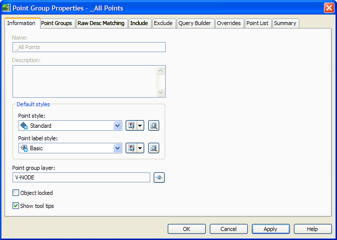
6) Change the Point Label style to Basic
7) Click OK

At this point you should see points on the screen with a simple X symbol and labels showing point number, Elevation and Description.


8) Save the file as new-topo.dwg in the same directory as the text file.

Now, to make the text around our points a little smaller we are going to change the scale of the drawing.
9) In the Settings Tab, right-click the name of the drawing and select Edit Drawing Settings…


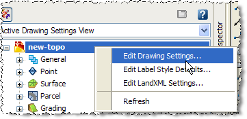
10) On the Units and Zone Tab, change the scale to 1” = 20’


11) Click OK

The text should now be smaller.

12) Save the drawing!

Great Job.

Can You Guess Who?

This is a doodle I made of a Civil 3D guy who came to train us. As you can Tell I was ENTHRALLED by the concepts he was laying down.

Wednesday, December 27, 2006

Using Expressions to Add Degree of Curve to Curve Labels

Degree of Difficulty:
1. In the Settings tab, expand the Alignment category until you see the Curve label area.

2. Right Click on Expressions and select NEW


3. In the new expression dialog box, fill in the name and description for the new property you are creating.

4. In the Expression dialog box, type in the calculation you wish Civil 3D to perform.

HINT: To see a list of the variables you are able to use, click Insert Property. In this example we chose Radius.

5. Click OK when you have completed entering the expression.


6. Now, right-click on the Curve Label Style to which you’d like to add the information. Select Edit…

7. In the Label Style Composer, go to the Layout tab.
a. Click on the New text component button.
b. Give the component a name
c. Set Allow Curved Text to true.


8. Still in the Label Style Composer, click in the contents area and click the ellipsis button.

This will open up the Text Component Editor.


9. Choose Degree_of_Curve from your list of Properties.
Any expressions you create will be available here.

10. Set Precision to desired value.

11. Click the blue arrow icon to send the text to the component window.

12. Add any additional text or symbols to your label.

13. Click OK when complete.

14. Click OK in the Label Style Composer.

15. You are now ready to use the style!

Friday, July 28, 2006

What I Know Already

This blog will be most useful for people moving from one civil software package to Civil 3D. I'll assume a decent knowlege of AutoCAD for any readers out there.

Personally, I am coming from a firm where I used Eagle Point software extensively. I was an administrator, trainer and civil engineer all in one. Frankly, from the short time I've been playing with Civil 3D, the two packages don't even compare. Design and changes go much faster in Civil 3D. There are a few things I think Eagle Point is stronger in. For one thing, Civil 3D needs a 3RD party converter to work with survey data. Even if you have a plain old ASCII comma delimeted file, you can bring it in, but Civ3d won't read standard linework. Grrrrr.... Eagle Point also will generate Plan and Profile Sheets for you, which Civil 3D will not. Lastly, painful though it may be to use, Eagle Point does have Hydrolics and Hydrology capability. I've been told "it's on the way" for Civil 3D.

The #1 thing I like about Civil 3D thus far is the CONFLICT CHECKING! Oh, the hourse of my life I wish I could have back. Luckily, I can use that time to...oh...make Plan and Profile sheets.

Friday, July 14, 2006

Eagle Point Terminology VS Civil 3D Terminology

Sorry this is so ugly, but the table I had up earlier was worse. If you would like a nice formatted *.doc version of this information, email me.

Thanks!


Eagle Point Term or Command = Civil 3D Term or Command

*Survey Stuff*
NodePoint = Point
Surface model = Terrain Model or Surface Model
Node Attributes = Point Label Styles
Field Code = Description Key
Node SymbolS = Point Style
Field Code = Raw Description
Description = Full Description
Line of Attribute Text = Text Component
Job = Network
Linework = Figures
*Surface Modeling / Grading*
Flow Paths = Water Drop
Switch Diagonal = Swap Edge
Breaklines:
Include ~Standard Break
Exclude
Soft Break ~Non-destructive
Include (along nodes) ~Proximity
Void Region = Hide Boundary
Prismoidal Volumes = Volume Surface or Comparison
Contours:
Intermediate =Minors
Index =Major
*Roadway*
Subprojects ~ Sites
Design Profile = Layout Profile
Typical Section = Assembly
Original Ground Cross Section = Sample Line Section
Corridor Width = Swath Width
Alignment + design profile + typical section = Corridor
Slope Conditions and Condition Table = Subassembly
Query Cross Section and/or Step Through Modifications = View/Edit Corridor
Section
Format Library = Band Set
PT Code = Marker Point
“Create Surface Model From Road” = Properties>
Slope Projection Options = Grading Criteria
Catch Points = Daylight

*General / Other*
Lots = Parcels

Welcome

Share my journey of discovery as I learn Civil 3D by AutoDesk!